The Great Alpine Passes: A Driver's Guide to Four High Roads
The Stelvio, the Grossglockner, the Route des Grandes Alpes and the Furka-Grimsel loop, measured by what each one asks of car and driver.
The Alps hold dozens of celebrated roads, but four of them define the canon for different reasons: one for its hairpins, one for its engineering as a toll panorama road, one for its scale as a multi-day itinerary, and one pair for the way two passes combine into a single loop. None is a circuit. All are public roads with opening seasons, traffic rules, tolls and weather that can change within the hour. This guide covers what each road is, what it demands, when to go and what to plan for. It assumes a well-maintained car and a driver who respects mountain traffic.
None is a circuit. All are public roads with opening seasons, traffic rules, tolls and weather that can change within the hour.
Passo dello Stelvio, Italy: the 48 hairpins
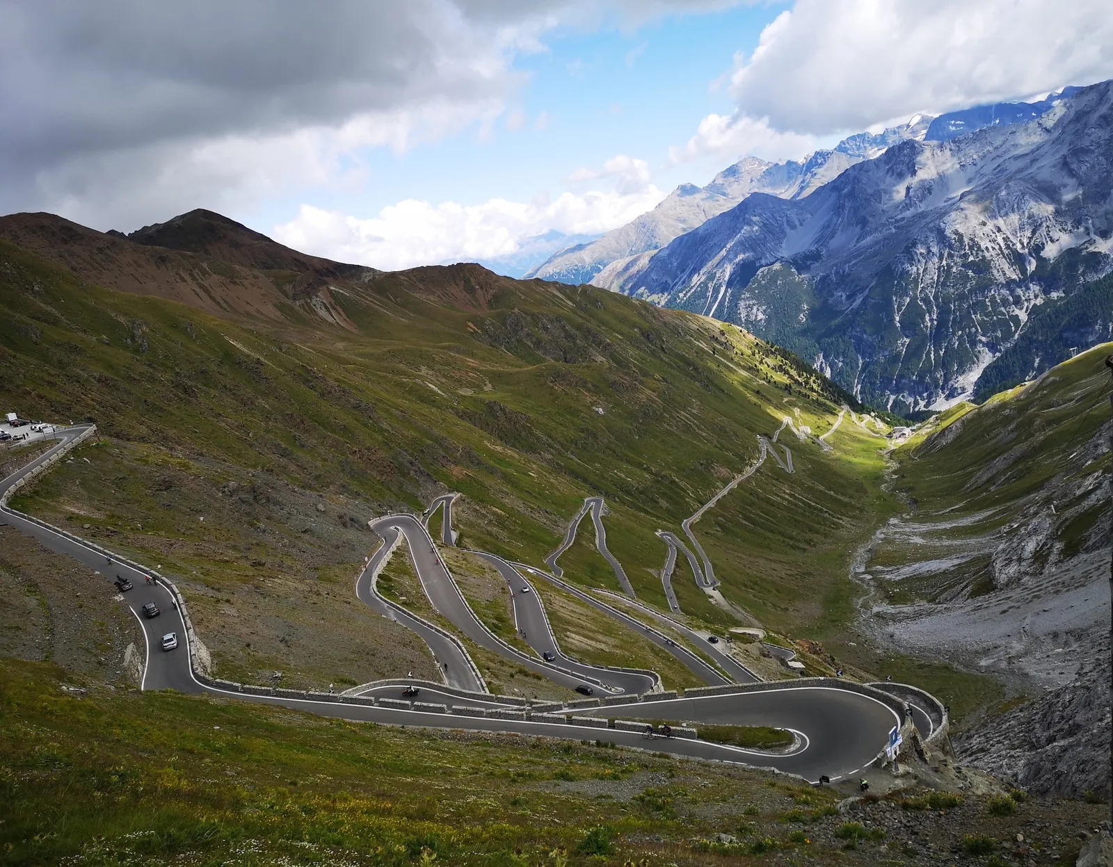
The Stelvio rises to 2,757 metres, making it the highest paved pass in Italy and the second-highest in the Alps. The road was built between 1820 and 1825 by the Austrian Empire to connect Lombardy with the rest of Austria, and it retains the character of that engineering: 75 hairpin bends in total, 48 of them on the north-eastern ramp above Prato allo Stelvio, each marked by a numbered stone.
The two ascents differ. From Bormio in Lombardy the climb runs about 21 kilometres at an average gradient near 7.1 percent, steeper and more direct. From Prato the climb is longer at around 24 kilometres, slightly gentler, and it carries the famous numbered sequence. Both sides are narrow, with gradients up to 16 percent reported on the steepest ramps, and the road is shared in summer with large numbers of motorcyclists and cyclists.
The pass is typically open from June to the beginning of October, closing with the first heavy snow. In peak summer the road can be congested with caravans, tour buses and motorcycles; early morning remains the best time to drive it. One day each August the road closes to cars entirely for the Stelvio Bike Day, when thousands of cyclists take over the hairpins. There is no toll. Fuel is a valley-town affair: fill up in Bormio or Prato before climbing, since the summit offers parking, cafes and a cable car rather than pumps. On the descent, sustained braking overheats pads quickly; engine braking in a low gear is the correct technique, and it is one these hairpins will teach on their own.
Grossglockner Hochalpenstrasse, Austria: the panorama toll road
The Grossglockner High Alpine Road is a different proposition: a purpose-built scenic toll road, 48 kilometres long with 36 bends, climbing through Hohe Tauern National Park to the Hochtor at 2,504 metres. Conceived in the late 1920s as Depression-era employment and tourism policy, it was built between 1930 and 1935 and opened on 3 August 1935. It now draws more than 900,000 visitors a year.
The surface is wide, well engineered and modern by alpine standards, but the demands are those of altitude and exposure. Weather shifts fast above 2,000 metres, and the road rewards steady pace and disciplined cornering over speed. The optional detour to the Edelweissspitze reaches 2,571 metres, the highest point reachable by car, and the Kaiser-Franz-Josefs-Hohe spur offers the classic view across the Pasterze Glacier to the Grossglockner itself at 3,798 metres, Austria's highest peak.
The road is generally open from early to mid May until early November, with hours that lengthen in high summer and a formal ban on night driving. In 2026 the day toll for a private car is 46.50 euros, paid at toll stations near Ferleiten in the north or Heiligenblut in the south; reduced rates apply to electric and hydrogen vehicles, and 65 charging points are distributed along the route. Drivers arriving via Austrian motorways need the motorway vignette, a separate requirement with meaningful fines for non-compliance. Plan a full day: the road is designed around twelve stopping points, and rushing it misses the point.
Route des Grandes Alpes, France: the 720-kilometre itinerary
The Route des Grandes Alpes is not a single road but a themed itinerary of about 720 kilometres from Thonon-les-Bains on Lake Geneva to Nice on the Mediterranean, crossing around 16 named cols. Construction began in 1909, the route opened in 1913, it was fully paved by 1937 and took its current name in 1950. It is signposted throughout with its red and white logo, stitched together from departmental roads across the Savoie, Hautes-Alpes and Alpes-Maritimes.
The statistics explain the reputation: the high passes are open to cars from June to October, and the route's crown is the Col de l'Iseran at 2,770 metres, the highest point on the itinerary, with the Col du Galibier (2,645 metres), the Col d'Izoard (2,360 metres) and the Col de la Cayolle (2,326 metres) among the other great climbs. These are Tour de France roads, and in July the itinerary shares its tarmac with the race's crowds and road closures, which is worth checking before committing to dates.
The demands here are those of endurance rather than any single climb. Four days is the disciplined minimum; six to eight allows the route to be driven as intended. The departmental roads carry no tolls, fuel is available in the valley towns along the way, and the surface quality varies more than on the Grossglockner, with narrower sections on the southern cols. The Iseran, Galibier and Bonette variants deserve respect for altitude: above 2,500 metres, weather and temperature can turn within minutes, and snow can linger on the verges into July.
Furka and Grimsel, Switzerland: the paired loop
The Furka (2,436 metres) and the Grimsel (2,165 metres) work best as a pair, linked at Gletsch in a loop of roughly 60 to 70 kilometres that also takes in the Rhone Glacier. The Furka carries the cinema fame: the Goldfinger sequence was filmed on its curves. The Grimsel crosses a granite plateau of reservoirs and dams, a more austere and industrial landscape that contrasts with the Furka's glacier views.
Both passes are narrow and winding, with steep drops and hairpin sections, though the surfaces are well maintained and signed, with guard rails on the exposed stretches. Traffic in high summer includes a high proportion of motorcycles and touring coaches; the roads are at their best early in the day. The typical season runs from May to October, with the Furka reopening after winter in late May in 2026. Winter closure is absolute: these are not roads to attempt outside the season.
Switzerland's passes themselves are free, but the motorway vignette at 40 Swiss francs is mandatory for reaching them by highway. Drivers should note that the Swiss parliament approved, in March 2026, a proposed transit fee of around 21 francs for foreign vehicles crossing the country without a significant stay; it remains at the draft-law stage and is not yet in force, but it signals the direction of Swiss road pricing.
Planning notes for all four
Altitude is the common factor. Naturally aspirated engines lose output as the air thins; turbocharged cars are less affected, but every car benefits from fresh brake fluid and healthy pads before a week of descents. Mountain weather rewards layers, a full tank, and a flexible schedule: fog, hail and sudden temperature drops are normal above 2,000 metres even in August. Start early, share the road with cyclists and motorcycles, and treat each pass as a full-day commitment rather than a segment to be hurried. The roads have been there for a century or more; they are not going anywhere, and the best driving on them is unhurried.